 |
| Arborway looking west. Elevated orange line in foreground. Granite Rail viaduct in background, Casey Overpass above. c.1970s photo: Library of Congress/HAER |
 |
Arborway looking west. South Street and Hampstead neighborhood in distance. c. 1920
|
|
|
I’m stepping outside the boundaries of what I usually do
here to write about an important public works project in the planning stages for my
neighborhood. The Casey Overpass, an unsightly and dangerous fly-over that has
spanned the Forest Hills section of Jamaica Plain, Massachusetts since the
early 1950s is soon to be torn down and replaced by The Casey Arborway, a tree-lined boulevard that
represents a tremendous opportunity to rationalize traffic patterns in the area
and re-knit substantially broken connections within Frederick Law Olmsted’s
beautiful string of narrow but vital parks and parkways known as the Emerald
Necklace here in Boston. For several months I've been researching the history and evolution of this location - what Olmsted's plans for it were, how it became like it is today, and what it might become in the future with careful and thoughtful planning. The following is a personal and opinionated view of what I've learned. Any errors of fact or interpretation in the way I've paraphrased source material are my own.
 |
| Ward 11 map, 1924 |
Forest Hills has been a significant transit
hub for two hundred years - a crossroads where pedestrians, railroads, horse-drawn carriages, trolleys, cars, cabs,
buses, elevated trains and subways have all converged to provide industrial, recreational and
commuter connections for the residents of Boston, Jamaica Plain and the region. Over many decades these links have
evolved somewhat haphazardly, coming and going through time while leaving lasting scars in the
landscape. As each transit mode has been replaced by later technologies, the legacies of their presence have accumulated and contributed to the confused connections that exist on the ground today. Along the way a vibrant
neighborhood has grown up in the area and differing needs and priorities have taken hold within the community through time.
My home abuts this section of the parkway known as the Arborway, and I
have a keen interest in plans for the future here. I've followed avidly through a heated public process with an open mind but with confidence in the professionals involved and faith in my neighbors who have been participating in the process as advocates of one stripe or another.
 |
| Forest Hills looking north in 1925. Left-right dark stripe is the Arborway. |
To my eye, and as a neighbor who has chosen to live in Jamaica Plain for
its great diversity and abundant greenspace, the plan to eliminate the bridge is a huge opportunity for my community. The city of Boston will get a more rational street layout and a reconnection between Jamaica Pond, the world-class
Arnold Arboretum and Franklin Park. We'll get a tree-lined boulevard
instead of a massive and unnecessary fly-over for transitory drivers. We'll
get blue sky and open space, an inviting network of bike paths and
pedestrian ways where bridge abutments and ramps now stand. Commuters heading for the Orange Line at Forest Hills Station from northern Jamaica Plain will get a new Head House for the subway station that eliminates
the need for many to cross the East-west flow of traffic. And Jamaica Plain will get a newly redesigned plaza where the buses currently idle that
may serve as valuable community space. Forest Hills and Jamaica Plain
have the potential to become a showcase gateway for southern Boston, a
more functional transit hub and potentially a recreational mecca for the residents of the city and beyond.
I'm hopeful that the evolving plans will continue to be informed by the rich history of the area. Though I believe it is unrealistic to
wish for a return to an idyllic 19th century vision of parkland in the midst of this very real 21st century transportation dilemma, I believe that the local heritage can and should inform the decision making. Where a large, ugly overpass now stands, a
beautifully landscaped parkway once existed - and, in adapted form, it may well exist again:
 |
| Arborway looking west in Winter c. 1900. South Street intersection. |
 |
| Arborway, Arborway Rd, Hampstead Rd. and South Street looking North. c. 1910 |
 |
| Casey Overpass looking East c. 2013. Now reduced to two lanes for safety. |
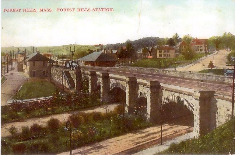
In the late 19th century, several factors were in motion at once that had a profound and lasting impact on this area. Renowned landscape architect Frederick Law Olmsted was at work designing the Arnold Arboretum and the string of Boston Parks that came to be known as the Emerald Necklace. And concern about the street-level safety of railroad crossings within Boston led to the elevation via berm of the Boston and Providence Rail lines. Many rail bridges were built to accommodate cross traffic through southern Boston, but only one - the Forest Hills Viaduct over the new Arborway parkway - was designed by architects. In 1898, a series of granite archways designed by the firm of Shepley, Rutan and Coolidge rose over the parkways at Forest Hills Station and stood here until 1983:
 |
| Boston and Providence RR Viaduct and The Arborway, 1907 |
 |
| Forest Hills viaduct crossing Arborway |
This viaduct spanned two carriageways, two bridle paths and a pedestrian path that once carried
travelers along the Arborway from Jamaica Pond, past the Arnold
Arboretum, through Forest Hills and on to Morton Street and Franklin Park.
Olmsted had
originally intended for the separate sections of the Emerald Necklace parkways to be
lined with differing species of trees that would signal the character of each portion. For the
Fenway he planted Norway Maples while the Riverway received American Lindens and
the Jamaicaway got the Northern Red Oaks that still line the parkway today. But for
the Arborway, Olmsted wanted Cucumber Magnolias and Tulip Trees – flowering
varieties that were to serve as an invitation to and an echo of the bordering Arnold Arboretum.
Those plans were not fully carried out, and instead the parks superintendent switched
to Red Oaks for the entire run to Franklin Park. While the oaks were still small and the canopy open, flowering rose shrubs were planted in between the trees along the Arborway:
 |
| Shrub roses along Arborway. Viaduct in distance. Arborway Hillside to left. |
Beginning in 1909, just east of that heavy rail viaduct, Washington Street was capped by the elevated Orange
Line which ran for miles towards Boston. Forest Hills was the end of the line
and home to a large station that dominated much of the site. Sidings and a switching yard flowed out to the south:
 |
| Forest Hills Elevated Station. Note trolley barn underneath. |
 |
| Elevated Orange Line with B and P rail viaduct in background, 1970s photo: Marty Bernard, www.railpictures.net |
The street level where Forest Hills Square once stood was also host to a trolley yard and turnaround for
the carriages that ran down Centre and South Streets in Jamaica Plain. This must have created a confused traffic situation on the ground that I imagine to have been a bit like present day Cleveland Circle in Brookline, with cars and trolleys fighting for right of way, their bells dinging and horns blaring:
 |
| Forest Hills Square |
|
 |
| South St and Arborway, Jamaica Plain 1929 photo: Jamaica Plain Historical Society |
But the Jamaica Plain version was also shadowed by two elevated train lines
and the consequent obstacles of the underlying bridge abutments as well. As can be seen in this aerial shot from 1929, the two rail
lines were a significant interruption to the parkway landscape shown in the upper left. And with the
large bridgework, station and trolley traffic taking up much of the footprint the area
was deemed to be a significant bottleneck for car traffic by the time of the mid-century post-War boom in population.
 |
| Generally northward view. Boston and Providence rail on left, Elevated Orange line station on right |
Yet remnants of the Arborway landscaping survived throughout the first half of the 20th century between the rail lines. Like Virginia Lee Burton's The Little House, some of the parkway character held on while the industry of the city evolved around it:
 |
| The Arborway's trees and shrubs between the two rail lines, 1910. |
By the 1950s, travel by auto was becoming so dominant that
calls for a bridge to span these two elevated train lines and the trolley
turnaround grew louder. And so was born the Forest Hills (later Casey) Overpass. In the style of highway engineering of the time, it was to be
a long, wide arch dominating the daylight and skyline, carrying the East-West through traffic over the area, with it's feet stepping around and between the North-south roadways, the two rail lines and the trolley turnaround:
 |
| 1951. Casey Overpass deck under construction above the elevated train line at Washington Street. photo: Anthony Sammarco/Jamaica Plain Historical Socity |
 |
| Casey Overpass looking to the east. Shattuck Hospital in distance. Toole Square in foreground. photo: Jamaica Plain Historical Society |
The street-level disconnection between this southern portion of Jamaica
Plain and it’s northerly sections was exacerbated even further. To build the overpass, the Arborway
parkway underneath was destroyed. Half the former East-West street level thoroughfare was taken up by
bridge abutments and ramps. A significant portion of the Arborway Hillside and a
large home on Arborway Road were also destroyed for a westerly on-ramp from South Street, resulting in the construction of a
barren stone retaining wall topped by a chain-link fence near Hampstead Road.
 |
| Westerly on-ramp at South Street and Arborway Road showing the retaining wall built in the 1950s |
 |
| Arborway Hillside retaining wall looking to east. |
The tangle of ground-level intersections in the gloomy
shadow of the bridge became even more difficult to navigate for cars, buses, pedestrians and cyclists below. The neighborhood was left with ill-conceived turning options for cars, dangerous crosswalks for pedestrians and even awkward and confusing street names while some of the east-west traffic from elsewhere flew overhead.
 |
| Easterly ramp at South Street/Washington |
 |
| Under the westernmost abutments |
During the 1970s a huge public outcry halted state plans to build a cross-town freeway through southern Boston, but not before some buildings fell to eminent domain takings. In the 1980s the Southwest Corridor project utilized some of this land, combining the
elevated heavy rail lines and the elevated orange line and then sinking both in a trench
running five miles from the Back Bay to Roslindale. Miles of parkland and bike paths eventually lined
the new corridor where homes, industrial buildings and rail yards once stood.
The elevated lines and stations and the old stone viaduct were torn down, replaced by the
current Forest Hills Station.
 |
| The New Forest Hills Station alongside the old, late 1980s. |
 |
| Orange Line subway on left, regional commuter rail and Amtrak on right. |
 |
| Pedestrian and bike paths run the length of the 4.7 mile long, 52 acre Southwest Corridor Park |
Shortly thereafter, the traffic-snarling
on-street trolley traffic was eliminated on Centre and South Streets through downtown Jamaica Plain, and eventually the trolley turnaround at Forest Hills Station was converted to a busway for the 39 bus.
So… today we have a massive Overpass built to span three
transit routes which no longer exist at street level. With it's huge footprint and ramps, it is an impediment to street level traffic through the neighborhood as well as to and from neighborhoods to the south like West Roxbury, Roslindale, Hyde Park and Dedham. And the Overpass is irreparably crumbling. For safety, the bridge traffic has
been reduced to one lane in each direction, and anyone traveling more than 20 miles an hour on it risks life and axle. Much of the span has been covered
with netting to keep parts and pavement from falling to the streets and sidewalks below.
As of this writing (May 2013), it has been more than a year since a lengthy public process resulted in the selection of what's been called the "at-grade solution": The Casey Arborway. After intense and ongoing community debate, peer-reviewed traffic studies and engineering plans have determined that a bridge is unnecessary and that it's removal creates an opportunity for improved traffic flow and quality of life. This has resulted in a decision to replace the crumbling edifice with something much more like Olmsted's parkway than many residents can imagine.
This draft open space plan from April 2013 shows the current state of design, which is subject to further refinement:

Yet the memory of the contentious 1970s cross-town highway period remains a significant clarion
call for some long-standing members of the community, and the legacy of stopping the elevated highway in the 70s has been used as
justification for trying to roll back the decision to eliminate the
bridge now. Ironically, some of those who were opposed to elevated highways forty years ago
are some of the very same voices calling for building a new elevated bridge here now.
Despite the peer-reviewed studies and computer models showing that
travel times will be comparable with a newly designed at-grade boulevard
- and that, not insignificantly, the tax dollar savings for the citizens of the Commonwealth would be huge - some in the community
have had a difficult time accepting either the data or the decision.
After all I've read and heard on this topic, I'm firmly in favor of the chosen course - the at-grade solution - and I'm in favor of
coming together as a community to help craft the best possible solution from the opportunity presented.
Communities all across the country (including Boston) have found that
eliminating massive highway-style viaducts can create vibrant open space and rational thruways
without hampering the flow of traffic. I firmly believe this will be the
outcome here.
But there is still work to be done. Landscaping plans are not final. Many details remain to be worked out in a vigorous public process. My neighborhood in particular (in the upper left corner of the draft Open Space plan above) is one of the least green sections proposed. Partly that is a result of the on-ramp retaining wall legacy of the 1950s, but partly it's because this is a "work in progress", one rapidly being amended thanks to strong community input. There are specific and very local issues I'd like to see refined - which I'm sure is true for many abutting neighbors throughout the project. Perched on the edge of a mid-century retaining wall myself, I'm hoping for improved views and traffic flow, for a softened greenscape and the maximum reasonable effort to enhance the community outcome while a 21st Century transportation solution is crafted on our front door.
I've been involved in educating my neighborhood about the facts and details as they've become known, and in helping to spread the word about what once was and what might be. I've hosted outreach meetings for the neighborhood with the parties responsible for the outcome, and our voices have now been heard. The proof is in the pudding, of course, but the authorities have been responsive to our rational and reasonable voices so far. We're looking to refine the outcome while there is still time, and though we'd certainly like to survive the construction process over the next few years relatively unscathed, we're looking past that short-term inconvenience to the long-term legacy being created now. I'm hopeful that it will be a legacy worthy of the one we've inherited.
As Frederick Law Olmsted himself said in his last report on Franklin Park, quoting John Ruskin:
"Let it not be for the present delight, nor for present use alone; let it be such work as our descendants will thank us for..."
###
I'd be terribly remiss if I didn't acknowledge the vast amount I've learned and paraphrased from the work of Richard Heath who's "History of Forest Hills" is available on the website of the Jamaica Plain Historical Society here:
http://www.jphs.org/locales/2004/5/15/history-of-forest-hills.html
Cynthia Zaitzevsky's "Frederick Law Olmsted and the Boston Park System" is a terrific book, one I've pored over repeatedly and it offers a wealth of information on the creation of the Emerald Necklace.
For information about other communities re-casting their highways and
viaducts see in particular the Congress for New Urbanism's Highways to
Boulevards project:
http://www.cnu.org/highways
MassDOT's website dedicated to the Casey project has been a wealth of information for the community. Filled with documents, data, plans, meeting transcripts and other resources it is the place to go if you'd like to see "how they make the sausage" in a massive and evolving inter-agency public works process. I thank them for their dedication, responsiveness and ingenuity:
http://www.massdot.state.ma.us/caseyarborway/Home.aspx
Other contributors to the J.P. historical society have also unknowingly been helpful to me as I pursued this interest, as has the staff of the Arnold Arboretum, the JP Branch of the Boston Public Library, that of the Arborway Coalition, a host of online rail buffs who seemed to know their stuff, various archivists throughout the city as well as representatives of MassDOT and their consultants. The community members and advocacy groups that have been a part of this project's planning all along have also certainly helped to shape both my thinking and the project itself.
Many of the images here originated in the collections of others, and though some are public domain in nature, all were used without their permission or citation. For that I can only confess to being a reader with a large appetite and not a professional scholar. To any that I've harmed or misrepresented, I beg forgiveness.
Clay Harper
Hampstead Road
Jamaica Plain
May 2013


